Family Safari Volcanoes National Park
August 15, 2026
Murchison Falls to Kibale Drive Time Uganda
August 16, 2026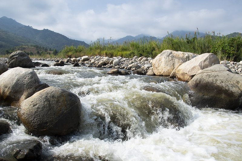
Hidden in the folds of the Rwenzori Mountains, River Nyamwamba Uganda carries snowmelt down from Africa’s famous “Mountains of the Moon” straight into the heart of Kasese District. This glacier-fed river has shaped the culture, farms, and daily survival of the Bakonzo people for generations, and it now draws growing numbers of travelers who want to see a living, breathing mountain ecosystem up close. At Zamunda Travels, we treat this river as one of western Uganda’s most underrated adventures, and this guide walks you through its origin, its people, its dangers, and how to experience it responsibly.
The Origin and Journey of River Nyamwamba Uganda
Every great river tells a story of altitude, ice, and gravity, and River Nyamwamba Uganda tells that story better than most. It begins high on the slopes of Mount Rwenzori, where equatorial glaciers cling to the peaks despite sitting almost on the equator. As those glaciers melt, the water gathers into fast, cold streams that tumble down through forest, moorland, and rocky gorge before reaching the valley floor near Kasese town.
Glacial Beginnings on the Mountains of the Moon
The Rwenzori range earned its nickname, the Mountains of the Moon, because ancient geographers believed its snowy peaks were the mysterious source of the Nile. Today we know the truth is almost as remarkable. Meltwater from these glaciers feeds several rivers, and River Nyamwamba is widely regarded as the main river draining this side of the range. Because the water starts as ice, it stays remarkably cold and clear for a tropical African river, and this is part of what makes a Zamunda Travels expedition to the source so memorable.
Flow Through Kasese District Towards Lake George
After leaving the steep upper slopes, the river cuts through Kasese District and passes close to Kilembe, an area once famous for copper mining. It continues across farmland and settlements before finally emptying into Lake George, which sits within the Albertine Rift Valley and forms part of the wider Queen Elizabeth National Park ecosystem. This journey from ice capped peak to rift-valley lake gives the river an unusually dramatic elevation profile for its length, and it explains why the surrounding landscape shifts so quickly from alpine moorland to lowland savannah.
Exploring River Nyamwamba Uganda with Zamunda Travels
Travelers rarely expect a glacier river in equatorial Africa, and that surprise is exactly why River Nyamwamba Uganda belongs on a western Uganda itinerary. Zamunda Travels builds custom trips around the river’s most photogenic stretches, pairing riverside walks with wider Rwenzori hiking routes so guests experience both the water and the mountains that feed it.
What Makes This River a Must-Visit Attraction
The scenery along the riverbanks changes constantly, moving from misty highland forest to rolling green hills and glistening cascades within a single afternoon walk. Birdlife is abundant near the water, and the surrounding foothills offer some of the clearest views of the Rwenzori peaks on a good day. Because the river also carries deep cultural meaning for local communities, a guided visit with Zamunda Travels blends nature photography with genuine cultural exchange rather than a purely scenic drive-by.
The Cultural Significance of River Nyamwamba Uganda
For the Bakonzo people who live along its banks, this river is far more than a water source. Local tradition holds that the name Nyamwamba reflects the idea of abundance, a fitting description for a river that has sustained farms and households for so long. Many residents of the region also identify as Abanyarwenzururu, a term connected to the snowy highlands above them, which shows how closely local identity is tied to the mountain and its glacial rivers.
Oral tradition in the area also links the river’s moods to the spirits believed to inhabit the Rwenzori peaks. When the water rises suddenly and violently, some elders describe it as a form of punishment sent down from the mountain gods for wrongdoing in the community. Whether or not visitors share this belief, it reveals how deeply the river is woven into local worldview, and guides working with Zamunda Travels often share these stories directly from community members during river walks.
Livelihoods Along River Nyamwamba Uganda
Agriculture in this part of Kasese District depends heavily on a steady water supply, and for decades that supply has come from this single river system. The Mubuku Irrigation Scheme, one of the best-known irrigation projects in the region, draws on water connected to this river network to keep farmland productive even outside the rainy seasons. Beyond farming, households across the valley rely on the river for cooking, washing, and general domestic use, which makes its health a direct measure of community wellbeing.
Other rivers such as Mubuku, Ruimi, and Nyamugasani also drain this side of the Rwenzori range, but locals consistently describe Nyamwamba as the backbone of daily life in Kasese town and its surrounding villages. Any change in its flow, whether a dry spell or a flash flood, ripples quickly through markets, schools, and homes.
Climate Change and Flooding Risks Facing River Nyamwamba Uganda
The same glaciers that make this river so special are shrinking, and that retreat has consequences far beyond scenery. Long time residents describe rainy seasons that once fell predictably between March and June, and again from October to December, but now arrive with far less certainty. Rising temperatures across the Rwenzori foothills have made the once reliable climate pattern harder to read, leaving farmers guessing when to plant.
Alongside gradual glacier loss, sudden and violent flooding has become one of the defining hazards of life near this river. In May 2020, heavy rainfall caused the river to burst its banks, sweeping away the Kyanzuki Bridge and cutting off the main road between Kasese and Fort Portal at the Nyamwamba Bridge crossing. Roughly 1,252 people were displaced during major flood events in the Mubuku catchment that year, and property damage across the valley was severe. Flooding has recurred in the years since, repeatedly submerging low lying neighborhoods such as Nganji, Kibenge, and Nyakasanga, and periodically stranding patients and staff at Kilembe hospital. Because of this pattern, Zamunda Travels always checks current weather and river conditions before scheduling any riverside activity, and we recommend every visitor do the same.
Planning Your Visit to River Nyamwamba Uganda with Zamunda Travels
Timing matters enormously when you plan to see this river safely. The driest and most comfortable windows generally fall between June and August, and again from December through February, when trails are firmer and river crossings are calmer. Outside these windows, sudden downpours in the mountains can raise water levels within hours, so flexibility is essential.
Getting to the riverside attractions is straightforward once you reach Kasese town, where boda-bodas and taxis provide quick access to nearby viewpoints and trailheads. Pack waterproof hiking boots, a light rain jacket, and layers you can add or remove quickly, since temperatures shift fast as you move between valley floor and higher ground. Zamunda Travels strongly encourages hiring local guides for every river excursion, both for safety and because these guides carry generations of knowledge about the terrain, the water, and the stories tied to it. Supporting community-run stalls and craft sellers along the route also keeps tourism revenue circulating directly within the villages that depend on this river.
Frequently Asked Questions About River Nyamwamba Uganda
Where does River Nyamwamba Uganda begin and end? It originates from glaciers on Mount Rwenzori and flows down through Kasese District before emptying into Lake George in the Albertine Rift Valley.
Is it safe to visit during the rainy season? Flash flooding is a genuine risk during heavy rains, so Zamunda Travels recommends visiting during the drier months and always checking local conditions before any riverside activity.
Can travelers combine a river visit with Rwenzori hiking? Yes, many guests pair a riverside walk with broader Rwenzori Mountains National Park hikes, since the river’s upper stretches connect directly to popular trekking routes.
Final Thoughts on River Nyamwamba Uganda
Few rivers anywhere on the continent connect equatorial glaciers to rift valley lakes within such a short, dramatic distance, and that alone makes this a destination worth understanding before you go. Beyond the scenery, the river’s story is really a story about the people of Kasese, their farms, their beliefs, and the growing climate pressures they now face. Traveling here with Zamunda Travels means seeing the water, the mountains, and the community together, guided by people who know exactly how the river’s moods can shift and how to explore it well.